The increase in demand for high-resolution imagery and the advancement of drone technology focused on contributing significantly to the market growth and with more use cases emerging across the industries over the forecast period of 2024 to 2034. The market is estimated to reach USD 567.7 million by 2025 and will expand at a CAGR of 12.7% from 2025 to 2035 and will reached around USD 1,876.4 million by 2035.
Market Attributes and Growth Projections
| Attributes | Values |
|---|---|
| Estimated Germany Market Size in 2025 | USD 567.7 Million |
| Projected Germany Market Size in 2035 | USD 1,876.4 Million |
| Value-based CAGR from 2025 to 2035 | 12.7% |
Exclusive Offer: 30% Off on Regional Reports
Get a free sample report and customize your regions for a 30% discount on your regional report!
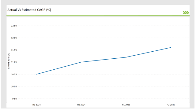
The table below outlines the semi-annual growth rate of the market, offering insights into industry trends.
| Particular | Value CAGR |
|---|---|
| H1 2024 | 11.6% (2024 to 2034) |
| H2 2024 | 12.1% (2024 to 2034) |
| H1 2025 | 12.3% (2025 to 2035) |
| H2 2025 | 12.7% (2025 to 2035) |

There is a steady growth trend in the aerial imaging market in Germany. Growth picked up from 11.6% H1 2024 to 12.1% H2 2024 (+50 BPS), an encouraging indicator of rebuilding market confidence. This trend continued in H1 2025 (12.3%) and H2 2025 (12.7%) - a sign of the ongoing investment in aerial imaging technologies.
| Date | Development / M&A Activity & Details |
|---|---|
| Jan-25 | Leica Geosystems partners with German municipalities to enhance urban planning with aerial imaging solutions. |
| Oct-24 | Airbus Defence and Space launches a high-resolution satellite imaging service tailored for European markets. |
| Mar-24 | Wingcopter secures funding to expand drone-based aerial imaging services in agriculture and logistics. |
| Sep-24 | Hexagon AB acquires a local geospatial firm to strengthen its aerial imaging capabilities in Germany. |
| Dec-23 | The German Federal Ministry of Transport announces new regulations facilitating the use of drones for aerial imaging. |
Increased Adoption of AI-Driven Image Analytics
AI-powered image analytics is booming in Germany’s aerial imaging sector, improving data processing and interpretation. Various industries such as agriculture, urban planning, and infrastructure monitoring utilize AI to interpret high-resolution aerial imagery for real-time decision making. AI is being used to provide accurate evaluations of land use, monitor vegetation health and predict disasters.
Through advancement of AI cloud rooftop inspection companies garner synergies with its aerial imaging solution, which increases operational efficiency while significantly lowering manual analysis time. The rise of demand for geospatial intelligence, combined with Germany’s rich AI research ecosystem, is propelling this trend, allowing aerial imaging to be more precise and actionable across various industries.
Growth in Drone-Based Aerial Imaging Services
In Germany, drone-based aerial imaging is growing rapidly, becoming an integral part of industries like construction, real estate, and environmental monitoring. For site inspections, asset management, and terrain mapping, drones offer affordable high-res imagery. This trend is being propelled by government initiatives promoting drone integration as well as more relaxed regulations for commercial drone operations.
Emerging technology such as LiDAR and multispectral sensors contribute to effective data collection better precision, enable businesses to take advantage of aerial imaging solutions with little or no infrastructure investment. This trend is likely to gain momentum with industries seeking scalable and real-time aerial data acquisition using drones.
Expanding Applications in Infrastructure and Urban Planning
The German aerial imaging market is propelled by the increasing adoption of high-resolution geospatial data for infrastructure development and smart city projects. Municipal governments and commercial builders employ aerial imagery for land mapping, zoning analysis and up-to-the-minute construction progress monitoring. As cities expand and investment in transport infrastructure increases, aerial imaging equips authorities with data in monitoring road networks, traffic patterns and environmental impact assessments.
This allows GIS with aerial data, mobile data and sensor data to support efficient urban planning. This driver is important as Germany specializes in sustainable infrastructure development and is a leader in deploying digital twin technology to manage urban centers.
Rising Demand for Precision Agriculture
Germany's agriculture sector uses aerial images as yet another tool to increase yields and manage crops. The farmers and agritech companies are focused on aerial imagery from satellites and drones to inform for soil health, crop diseases and irrigation levels.
The demand for aerial imaging-derived precision agriculture solutions is on the rise help to propelled by the country’s drive towards sustainable farming practices and resource-efficient agriculture. Technologies like hyperspectral imaging and thermal help to analyse the crop in real-time, thereby reducing the use of pesticide and enhancing the performance.

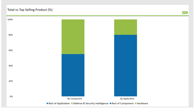
| Component | Market Share (2025) |
|---|---|
| Hardware | 45.0% |
| Others | 55.0% |
| Application | Market Share (2025) |
|---|---|
| Defense & Security Intelligence | 20.0% |
| Others | 80.0% |

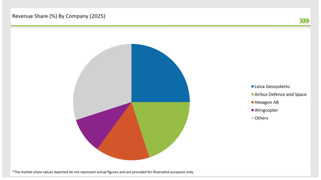
The Germany aerial imaging market is moderately competitive with key giants focused on innovation and partnerships.
| Vendors | Market Share (2025) |
|---|---|
| Leica Geosystems | 25.0% |
| Airbus Defence and Space | 20.0% |
| Hexagon AB | 15.0% |
| Wingcopter | 10.0% |
| Others | 30.0% |
Hardware, Software, and Services.
Defense & Security Intelligence, Geospatial Mapping, Urban Planning, Disaster Management, Energy & Natural Resources.
Government, Military & Defense, Agriculture & Forestry, Energy & Mining, Media & Entertainment, Construction & Engineering.
The market will grow at a CAGR of 12.7% from 2025 to 2035.
The industry will reach USD 1,876.4 million by 2035.
Key drivers include advancements in drone technology, increased demand for geospatial mapping, and investments in urban planning.
The Southern and Western regions of Germany lead in aerial imaging adoption due to dense urbanization and infrastructure projects.
The major players include Leica Geosystems, Airbus Defence and Space, Hexagon AB, and Wingcopter.
Explore Digital Transformation Insights
View Reports
Thank you!
You will receive an email from our Business Development Manager. Please be sure to check your SPAM/JUNK folder too.